Mining and Data science
 Creating 3D Geological Models with GemPy!
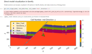
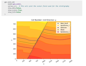
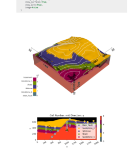
This code utilizes the GemPy library to create 3D geological models for analyzing geological layers and faults based on input data. The data is imported from CSV files containing surface points and orientation measurements.  What Does the Code Do?
 Defining the Geological Model:
Specifies the model’s dimensions in x,y,z
Creates a 3D grid to map layer distributions. Data Import:
Surface points: Represent the boundaries of geological layers.
Orientations: Define the dip and direction of layers. Data Analysis:
Helps understand relationships between layers and locate geological faults.
 Practical Applications:
Tunnel and mining design.
Geological risk assessment (e.g., earthquakes, landslides).
Planning major engineering projects like dams and roads.
 Technologies Used:
Python
GemPy Library
Do you have similar projects? Share your experience below! 
I hope to link mining with AI in future 
Mining DataScience AI Geology Surpac DataMine Vulcan Development Python GemPy